Measure Distance and Area on the Map
It is possible to measure both distance and area on the map and to add both as a drawing so that you can refer to it later. The measurement tools add measurements in increments as you draw on the map so that you have the distance for each segment as well as the overall distance or area. You can change the unit of measurement used for the Total Distance, Last Segment, Perimeter, and Area.
To measure distance on the map:
-
On the Analysis tab of the toolbar, click the Measure Distance tool, and then click on the map at the start of the distance you want to measure.

Measure Distance tool
-
Drag a line and click each time you want to change direction or to create a measured segment.
Whenever you click, the distance of the previous segment appears beside the line and the total distance covered to that point appears in the Total Distance box in the Measurement Info section of the toolbar.
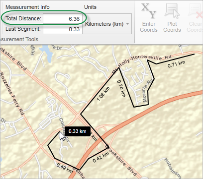
Measurement showing segment and total distances
-
To add the measurement as a drawing to the map, click the Add as Drawing tool either during or after you use the Measure Distance tool.

Add as Drawing tool
-
To remove a drawing, click the Erase Drawing tool, and then click on any part of the drawing.

Erase Drawing tool
- To remove a collection of measurement drawings, click
 .
.
To measure area on the map:
-
On the Analysis tab of the toolbar, click the Measure Area tool, and then click on the map at the edge of the area you want to measure.

Measure Area tool
-
Drag a line and click each time you want to change direction or create a measured segment of the perimeter.
Each time you click, the length of the previous segment appears beside the line and the total area and perimeter length display in the Measurement Info area.
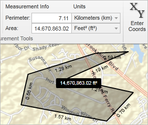
Measurement showing perimeter length, segment lengths, and total area
-
To add the measurement as a drawing to the map, click the Add as Drawing tool either during or after you use the Measure Area tool.
Add as Drawing tool
-
To remove a drawing, click the Erase Drawing tool and then click on any part of the drawing.
Erase Drawing tool
- To remove a collection of measurement drawings, click .
See also...
Add Markup
About Projects